Green Valley Water Enhances Decision Making Around New Development with AquaTwin Sewer

Background – A growing city with aging infrastructure

Green Valley Water (GVW) is a sanitary district located in central Arizona about 75 miles North-East of Phoenix. They serve a population of over 16,000 people, with 9,000 customer accounts and approximately 180 miles of sewer lines in the Town of Payson. That includes a mix of gravity sewer lines, low pressure sewer lines, force mains, as well as a reclaimed water distribution system. Green Valley Water began installing the sewer system in 1971, so some components are now over 50 years old.

Challenges – Data for decision making

The Town of Payson is growing, with regular requests for new subdivisions or proposed line extensions to support new development. The utility district weighs each request and determines whether it can be supported by their existing sewer infrastructure. However, before modernizing their data, they faced two challenges in this evaluation process, an incomplete model of their system and time-consuming manual processes.

  • Incomplete data – Since 1988, GVW maintained a skeletonized hydraulic model of their system. It wasn’t feasible to model every line and most of their maps were still on paper in 2017. It had 2-dimensional data stored on paper maps, but didn’t have any vertical data regarding how deep the pipes were underground.
  • Time-consuming evaluation process – As GVW received development inquiries, they needed to model these proposals to determine their impact on existing sewer systems. However, completing this modeling process manually could take days.

Solution – Implementing GIS and AquaTwin Sewer

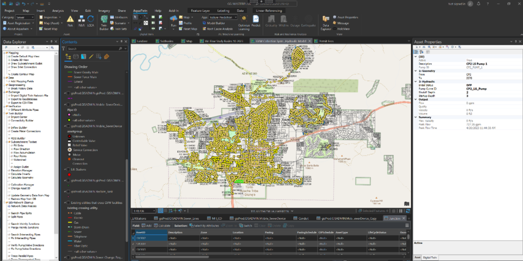
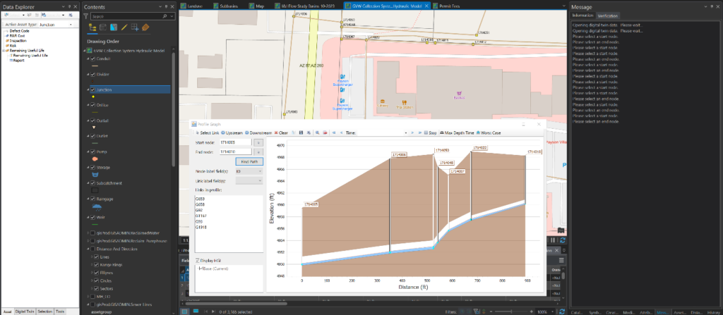
Green Valley Water took steps to modernize their data, building a complete GIS system and surveying their entire system. The district then implemented AquaTwin Sewer to model the effects of new development on Green Valley Water’s existing infrastructure.

  • GIS implementation – In 2017, Garrett Goldman, P.E. became the district manager and began to develop the utility district’s GIS system. Now the GIS model is nearly complete down to the smallest sections of pipe. GVW has surveyed 97% of the sewage collection system using a GNSS GIS receiver. The receiver enabled them to put eyes on the system and capture horizontal information as well as vertical information. With vertical information, the utility district can now understand how each subdivision will interact with the next. GVW now has a massive amount of good data that can be used for modeling and decision making.
  • Modeling with AquaTwin Sewer – Green Valley Water implemented AquaTwin Sewer to model new development proposals within their GIS system. Proposals that used to take a couple of days to model can now be completed within hours.
    • Dynamic Routing – In a dynamic routing extended period simulation, the team can see the effects of flow attenuation through the collection system and how it translates downstream. This is important because GVW has 14 lift stations in the service boundary, which have a big impact on pipe capacity.
    • Loading – The team uses AquaTwin Sewer to apply loading, creating a visual representation of the system that is repeatable. If things aren’t hooked up correctly, they can take action to modify where connections are made in the system.
    • Hydraulic Profiles – With AquaTwin Sewer, GVW can complete almost instantaneous profiles of a section of line and see the worst-case scenario on a line over an extended period of time. This information is especially valuable for regulatory reporting around line extensions.

Results – Enhanced decision making

Green Valley Water is now ready to respond to growing demand. Their complete GIS system provides the data they need and AquaTwin Sewer provides the modeling and visualization tools for rapid and accurate decision making.

  • Visual model for decision making – In the past, modeling would have to be completed using data tables, but now AquaTwin Sewer provides a visual representation of the sewer system. Garrett Goldman, P.E. says that this is tremendously faster and more accurate. The new visual representation gives him the ability to thoroughly look into each report as he makes decisions.
  • Support from Aquanuity – The Aquanuity team supported Garrett, meeting with him twice monthly as he set up the software and responding to his questions within a few hours. There were even a few occasions where the Aquanuity team went back and modified the software to include a feature he was looking for. Garrett said “I can’t say enough about the support that I’ve gotten in this. They’ve been very helpful.”
  • Integration with ArcGIS Pro – Garrett said that what sets the AquaTwin Sewer product apart is its seamless integration with ArcGIS Pro. He uses AquaTwin Sewer to model within his enterprise GIS portal with live data. This increases efficiency in modeling. Garrett said “I think it’s a game changer having ArcGIS Pro centric modeling. It just puts everything at your fingertips, so you’re not bouncing between platforms trying to pound a round peg in a square hole because it’s all right there and you can see what you’re doing as you’re doing it.”

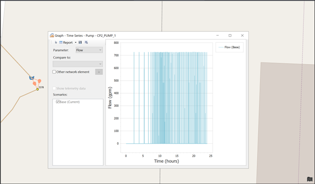
Green Valley Water is growing and regularly responds to requests for new development. To keep their existing sewer infrastructure functioning optimally, the utility district evaluates the effects of new development on loading, flow attenuation, and worst-case scenarios. With AquaTwin Sewer, GVW can now model all these scenarios within their ArcGIS Pro system.

“Integrated and compatible are two completely different things. AquaTwin Sewer is truly ArcGIS Pro integrated. It works effectively seamlessly with ArcGIS Pro and that is important to me because my data is constantly changing. As we get better and better at what we’re doing, being able to utilize that data is just incredible. I’m having fun, let’s put it that way.”

– Garrett Goldman, District Manager, Green Valley Water, AZ