Built exclusively on ArcGIS Pro®, AquaTwin Water is the next-generation AI-powered geocentric digital twin software for safe, reliable, sustainable and resilient water infrastructure. The software can effectively be used by both water utilities and their engineering consultants in all phases of the water infrastructure asset lifecycle. Design and size new water infrastructure, retrofit existing aging infrastructure, provide adequate capacity to fight fires, prepare wildfire resilience and power outage plans, estimate earthquake damages, forecast demands, optimize operations of tanks and pumps, reduce energy usage, investigate water quality problems, plan flushing operations, and prepare for emergencies. And armed with very fast and advanced simulation capabilities, users can model contamination threats and evaluate resilience to security threats, climate change or natural disasters.
A comprehensive 64-bit feature-packed modeling and analysis software extension for ArcGIS Pro®, AquaTwin Water lets utilities predict how their water systems will perform during disruptive incidents and determine how to best absorb, recover from, and more successfully adapt to such incidents and increase resilience. Its powerful simulation and analysis tools can help water utilities to explore the capacity of their systems to handle disruptive incidents and guide the planning necessary to make them more resilient over time. Users are now able to proactively solve or prevent problems, make confident decisions, execute quickly on a consistent basis, and plan and shape a better future for their communities.
AquaTwin Water Pro extends the powerful water quality modeling capabilities of AquaTwin Water with the important ability to model complex reactions between multiple chemical and biological species in both the bulk flow and at the pipe wall. It allows users the flexibility to model dispersion in dead-ends and a wide-range of chemical reactions of interest, including, auto-decomposition of chloramines to ammonia, the formation of disinfection byproducts, biological regrowth, combined reaction rate constants in multi-source systems, and mass transfer limited oxidation-pipe wall adsorption reactions. It also automatically calculates and assigns initial water quality equilibrium conditions for all links and nodes.
AquaTwin Water Pro adds a fully automated unidirectional flushing solution for creating pipe flushing plans to restore distribution system hydraulic capacity and improve water quality. It uses the minimum flushing velocity and shear stress criteria to design the proper sequences of hydrants to open and boundary valves to close for optimal cleaning while maintaining sufficient pressure at critical locations in the system.
ATLive extends the powerful hydraulic and water quality simulation functionality of AquaTwin Water to include real-time data acquisition and predictive forecasting. It delivers the power of real-time analysis (on-line modeling) for proactive management and operations of water distribution systems, and gives you visibility over blind spots (i.e., areas of the network lacking physical sensors). It lets users effectively simulate the performance of their water networks using real-time boundary conditions from SCADA. It can also be effectively used for real-time monitoring and diagnostics. Among its many powerful features, ATLive lets you:

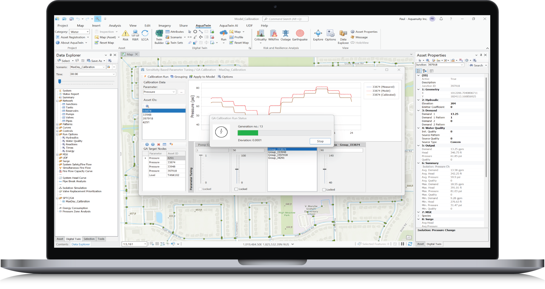

Using intuitive sliders for hydraulic network model parameters (including openness for valves/shutoff valve positions, pipe roughness coefficients and pump characteristic curves) you can interactively adjust each parameter and simultaneously see how this impacts model results in real-time and how closely it matches measurement data.
A PID (Proportional-Integral-Derivative) Controller is a generic closed-loop control algorithm that tries to maintain a desired set-point or a range on specific hydraulic variables by computing and applying a corrective action on pumps (i.e., pump speed) and dynamic valves (i.e., PRV, PSV, TCV, PCV) that adjusts the setting accordingly. For example:
Evaluate valve replacement prioritization by assessing the consequences of each valve failure in terms of the number of additional customers that would be affected if the valve were to fail.
Identify critical infrastructure by showing the impacts of partial or total failure of any pipe in the water network.
Quantify resilience and compare the benefits of different utility response strategies and long-term mitigation strategies.
A fully automated pipe criticality tool that runs Extended Period Simulations on a user-selected sets of pipes (e.g., transmission main pipes) to determine how critical a given pipe is in keeping water storage facilities filled, and if the pipe fails and is isolated, how long we would have before water storage levels drop below a set critical minimum level.
Earthquakes can be some of the most sudden and impactful disasters that a water distribution system can experience. An earthquake can cause damage to water system components including pipes and tanks that could take weeks, if not months, to fully repair. Additionally, earthquakes can cause power outages and fires. New version automatically:
Turn your water network model into a digital twin for real-time monitoring and diagnostics.
AquaTwin AI Agent transforms how engineers interact with their network models by combining advanced AI agents with powerful water infrastructure modeling capabilities, creating a comprehensive agentic GIS-centric modeling platform. It lets users use AI agents to analyze and troubleshoot network models, schedule and run various simulations, and generate reports and vivid dynamic dashboards using simple natural-language instructions.
Discover the full spectrum of tools and capabilities within the AquaTwin geocentric water infrastructure digital twin today.
Just click below to learn more or for a free demo.