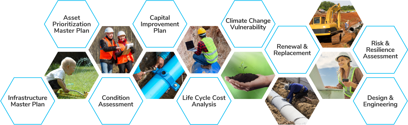
AquaTwin Asset is the leading AI-powered, simulation-based self-service water, wastewater and stormwater condition assessment and risk-based capital planning software for Esri® ArcGIS Pro®. It lets you address short-term infrastructure challenges through effective maintenance spending while extending the lifespan of critical aging assets under frequently changing conditions and building resilient and sustainable infrastructure for the future. And armed with advanced analytics and hydraulic network simulation capabilities, you can innovate and validate like never before.
Built exclusively on ArcGIS Pro®, AquaTwin Asset is a powerful feature-packed software for intelligent asset management of water, wastewater and stormwater systems. It lets utilities automate inspection work, measure asset performance, determine remaining useful life for all assets, evaluate infrastructure capacity shortfalls under population growth and climate variability, pinpoint assets at highest risk considering both likelihood and consequence of failure, identify root causes and patterns, and prioritize repair and replacement activities. It also enables them to prolong operational lifespan and value of aging assets, predict future asset performance, optimize capital planning, and secure business continuity resilience. Users are able to maximize their assets’ life cycles through sustainable infrastructure strategies and investments, making it possible to achieve the operational efficiencies and the future they envision while bettering their communities.
Key highlights:
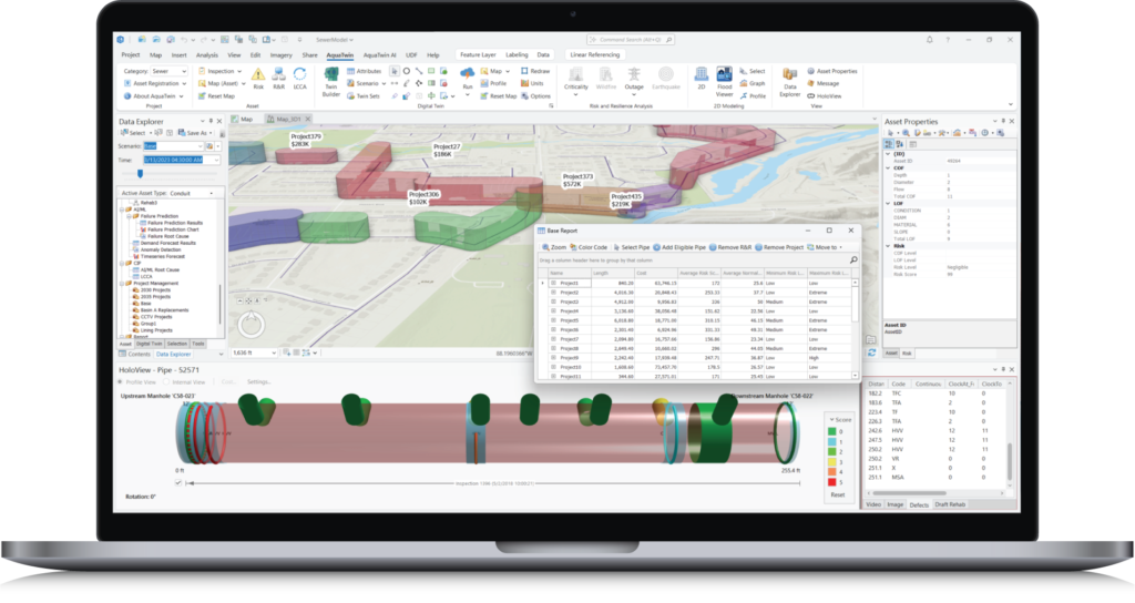
Urban drainage and sewer systems are facing increasing pressures due to an aging, deteriorating infrastructure further impacted by climate change, and rapid urbanization rates. Common risks in these types of environments include structural failures, service disruptions, flooding and associated environmental and public safety risks, and local area damage. AquaTwin Asset Pro was specifically designed to help utilities plan system improvements to strengthen and optimize their infrastructures at the lowest possible costs and highest efficiency. The software provides a powerful, seamless integration to the industry-standard EPA SWMM5 engine, adding cutting-edge hydraulic, hydrologic and water quality simulation capabilities and allowing sewer infrastructure capacity analysis results to be incorporated into risk/criticality assessment.
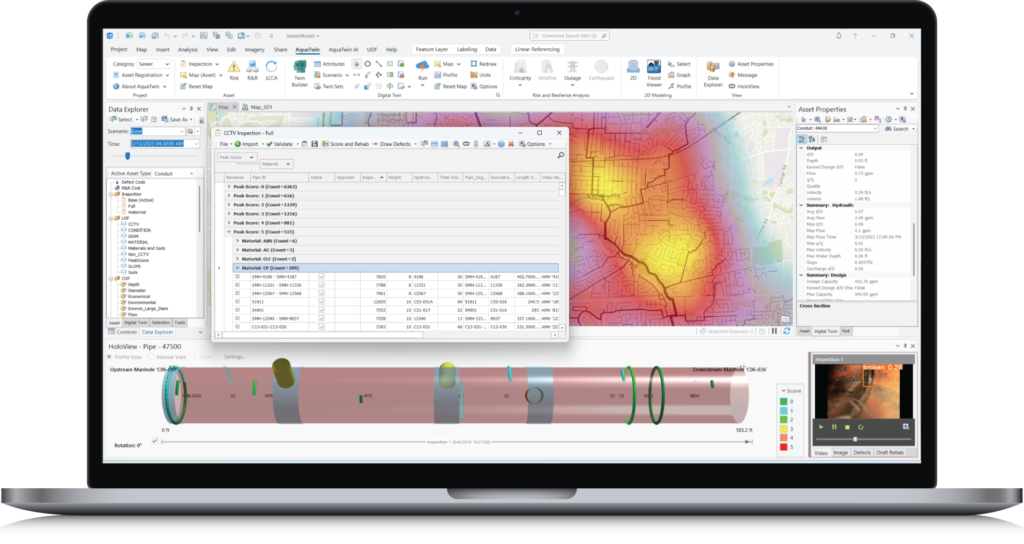
Build defect datasets from archived CCTV videos and use built-in Machine Learning to inspect more pipes, faster, better and cheaper and automate ongoing inspection projects.

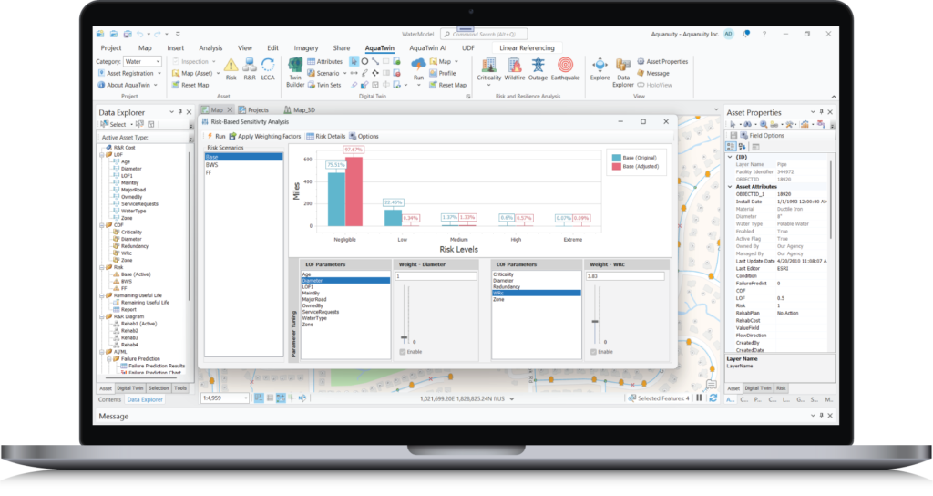
Use built-in analytics to determine and score the likelihood of failure, consequence of failure including hydraulic performance impact, and business risk exposure of each asset and better manage and prioritize repair.
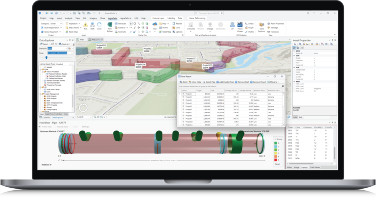
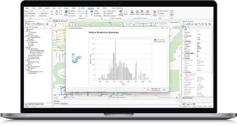
Leverage cutting-edge built-in algorithms to trace the root causes of (factors having the highest impact on) asset deterioration/failure and take corrective actions while driving long-term performance improvements. This includes pipes, valves, pumps and tanks.

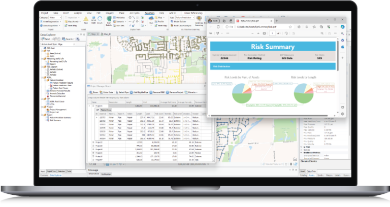
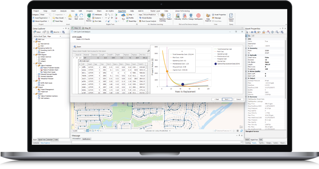
Use built-in risk framework, considering condition prediction, life-cycle cost analysis and criticality/resilience assessment, to prioritize needed improvement.
Simulate and analyze water infrastructure resilience; determine how your infrastructure will perform during disruptive incidents and how to best absorb, recover from, and adapt to such incidents.

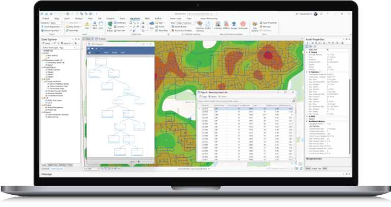
Create prioritized, costed capital improvement projects using fully configurable R&R decision diagrams to optimize capital investments.
Quantify system risk in terms of reliability, resiliency, and vulnerability. Identify hydraulic capacity shortfalls resulting from climate variability (e.g., changes in temperature and precipitation magnitude).
Water and wastewater utilities are struggling to close the widening gap between their wet infrastructure funding needs and availability. Let AquaTwin help you optimize the performance of your assets to increase reliability and availability, minimize costs, reduce operational risks, keep your community safe, and plan and shape a better, more sustainable future. What’s more? You can get up and running quickly with minimal training and start making informed decisions that will lead to financial, operational and business success.
Manage wet infrastructure capital assets to minimize the total cost of owning and operating them, while delivering the service level customers desire.
Predict and prevent breaks, locate leaks and reduce NRW, identify sustainable rates, and extend asset life without unnecessary costs.
Catalog and prioritize high-risk assets and allocate expenditures to yield the greatest return on investment.
Close the infrastructure funding gap and place your assets on the road to efficiency and sustainability using life cycle costing and reinvesting the savings in your wet infrastructure.
Develop optimal capital improvement plan and budget to gain governing bodies and stakeholders buy-in, and get better financial ratings and lower financing costs.

AquaTwin is built atop ArcGIS Pro® giving you complete access to generate maintenance work order and publish your asset prioritization plan to ArcGIS® Online/Portal.
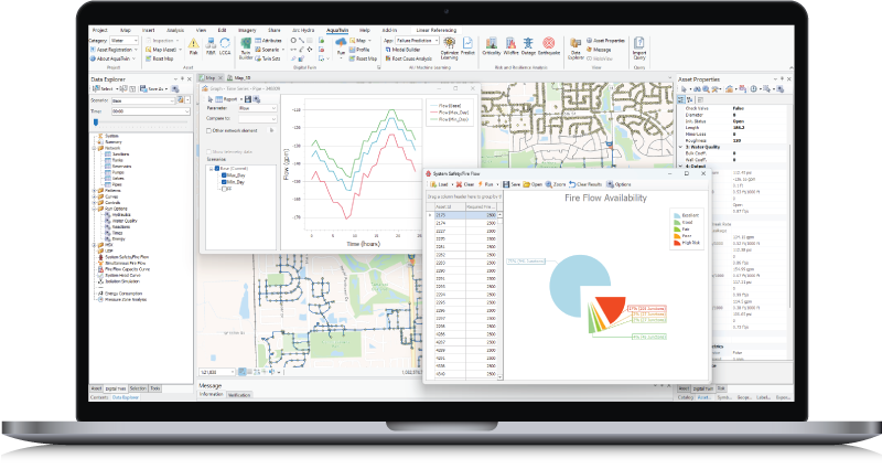
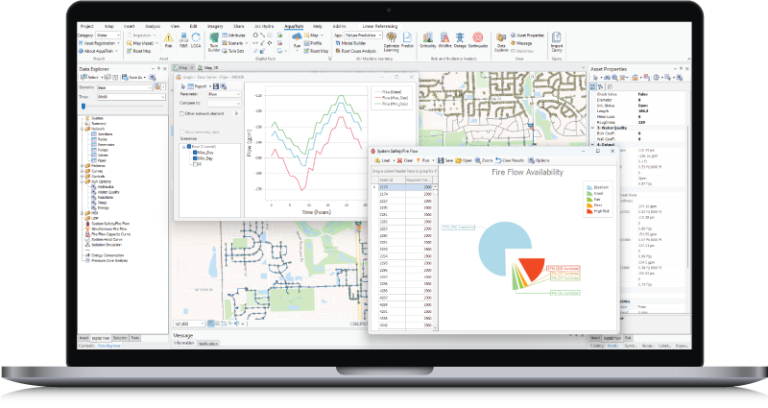
AquaTwin gives you the power to run and evaluate multiple hydraulic and fire flow simulation scenarios and see how your system will perform against requirements (e.g., identify where fire protection is inadequate).
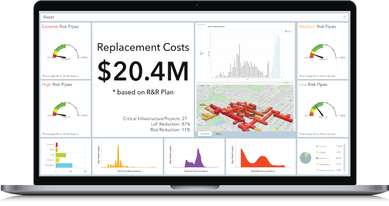
Directly connect to your maps and data and create custom dashboards that best inform stakeholders. Use dashboards to make data-driven decisions.
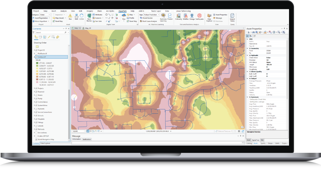
Assess the capacity of your water infrastructure to handle disruptive incidents and increase resilience.
Using intuitive sliders for risk factors (LOF and COF) you can interactively adjust each factor and simultaneously see how this impacts risk results in real-time. A novel approach for CIP development and Pareto (multi-objective) optimization!
AquaTwin AI Agent transforms how engineers interact with their network models by combining advanced AI agents with powerful water infrastructure modeling capabilities, creating a comprehensive agentic GIS-centric modeling platform. It lets users use AI agents to analyze and troubleshoot network models, schedule and run various simulations, and generate reports and vivid dynamic dashboards using simple natural-language instructions.
Discover the full spectrum of tools and capabilities within the AquaTwin geocentric water infrastructure digital twin today.
Just click below to learn more or for a free demo.