A comprehensive 64-bit feature-packed modeling and analysis software extension for ArcGIS Pro and powered by the latest version of the industry standard EPA SWMM 5 engine, AquaTwin Sewer leads the water infrastructure digital twin world in modeling capabilities, customer impacts, geocentric and geoprocessing technology excellence. It can effectively be used by both utilities and their engineering consultants in all phases of the urban sewer infrastructure asset lifecycle. All operations of a typical sanitary, storm and combined sewer system — from analysis and design to management functions such as water quality assessment, urban flooding, pollution prediction, real-time control and record keeping — are addressed in a single geocentric environment.
Plan, design, and analyze stormwater, sanitary and combined sewer systems; analyze hydraulic capacity; identify bottlenecks and mitigate overflows and blockages; size detention facilities and their appurtenances for flood control and water quality protection; map flood plains of natural channel systems; evaluate gray infrastructure stormwater control strategies, such as pipes and storm drains; design real-time controls; manage rainfall dependent inflow and infiltration (RDII); optimize BMP and LID designs; create cost-effective green/gray hybrid stormwater control solutions; evaluate resilient solutions; and meet SSO and CSO regulations. The software comprehensive scenario and alternative twin set management capabilities let users quickly create, run, evaluate, visualize, and compare an unlimited number of different pipe sizing, design and operational strategies, mitigation options, and network and pump configurations for improved decision-making.
A breakthrough innovation in sewer network modeling, AquaTwin Sewer lets you tap into the clean thermal energy of wastewater to power homes and businesses. By accurately calculating wastewater temperature dynamics in your sewer network taking into account the interaction and thermodynamics between bulk liquid (wastewater or stormwater), sewer headspace, pipe wall and the surrounding soil, AquaTwin Sewer gives you the power to evaluate the impact/magnitude of heat recovery on water temperature as well as the optimal placement of heat collection equipment.


Pushing the limits of sewer network model sizes and complexity, AquaTwin Sewer and AquaTwin Sewer 2D feature the powerful fast staggered-grid implicit finite difference scheme (FSGI) for solving the one-dimensional Saint-Venant equations in sewer/channel networks. It solves for link flows and nodal heads simultaneously at each time step by embedding the solutions to the Saint-Venant equations into a system of implicit linear equations. This ensures stability, accuracy, and computational efficiency. Furthermore, the method utilizes recurrence relations significantly reducing the size of the solution matrix and increasing computation speed compared to the more conventional implicit schemes. These computational advantages are imperative to effectively and efficiently model large and complex networks. It also enables wastewater utilities and engineering firms to save hours of engineering time, where project schedule is always critical.
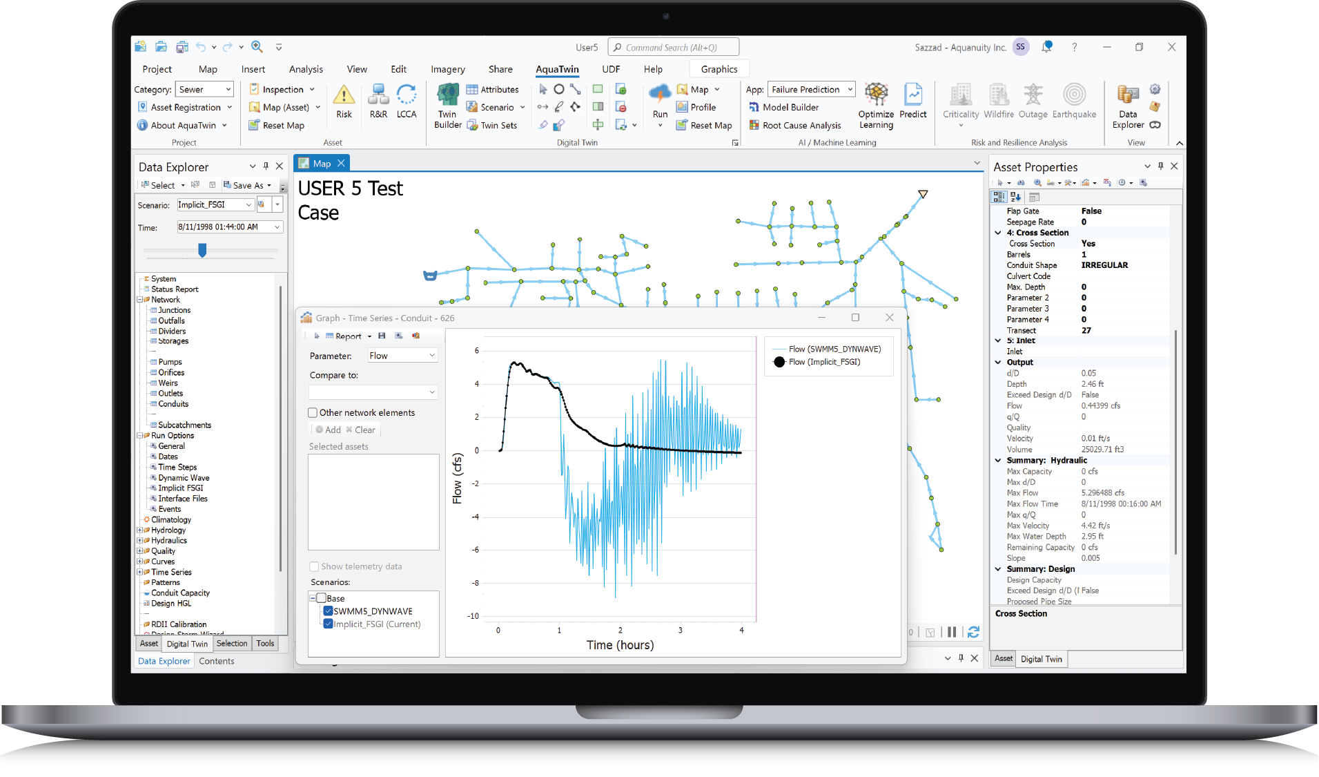
This white paper compares the computational performance of the explicit SWMM5 Dynamic Wave (DW) and the implicit Fast Staggered-Grid Implicit (FSGI) methods for solving the complete 1D Saint-Venant unsteady flow equations in sewer/channel networks. The two methods are benchmarked against the well-documented 19 EPA SWMM5 QA/QC test cases under equal accuracy tolerance as well as an actual sewer system. Results show that FSGI is more computationally efficient than SWMM5 DW for sewer network modeling and significantly outperforms DW by at least a factor of 8. The results also provide an insight into the limitations of SWMM5 DW in terms of numerical stability and mass conservation, problems that can be effectively overcome by FSGI.
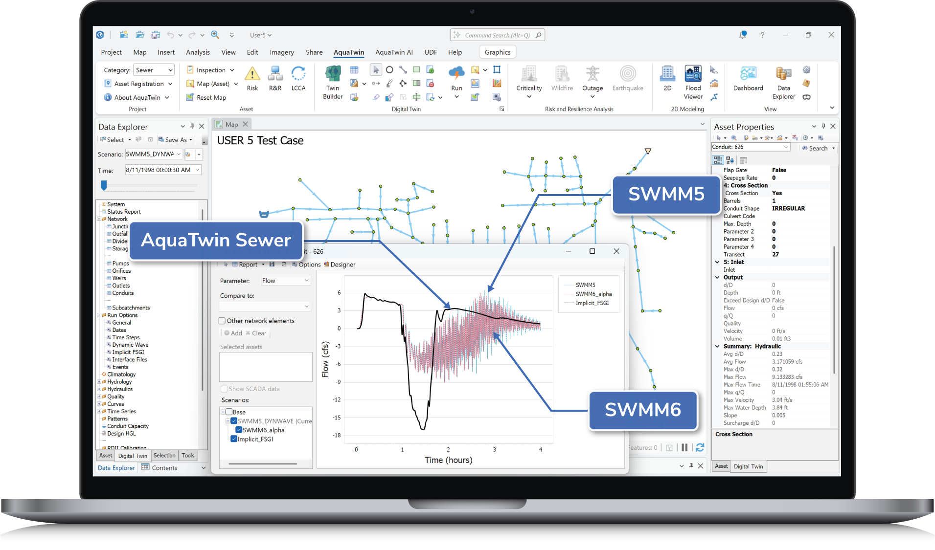
This comprehensive white paper compares three numerical approaches for one-dimensional (1D) dynamic sewer network modeling: the SWMM5 Dynamic Wave routing scheme, the emerging SWMM6 alpha Dynamic Wave enhancements, and the advanced Fast Staggered-Grid Implicit (Implicit FSGI) scheme. The three methods are benchmarked against the standard and well-documented 19 EPA SWMM5 QA/QC test cases under equal accuracy tolerance as well as using an actual sewer system. Results show that Implicit FSGI is more robust and computationally efficient than both SWMM5 and SWMM6. The results also provide an insight into the limitations of both SWMM5 and SWMM6 in terms of numerical stability and mass conservation, problems that can be effectively overcome by Implicit FSGI – opening new avenues for solving real-world sewer network problems with unprecedented accuracy, stability and speed.
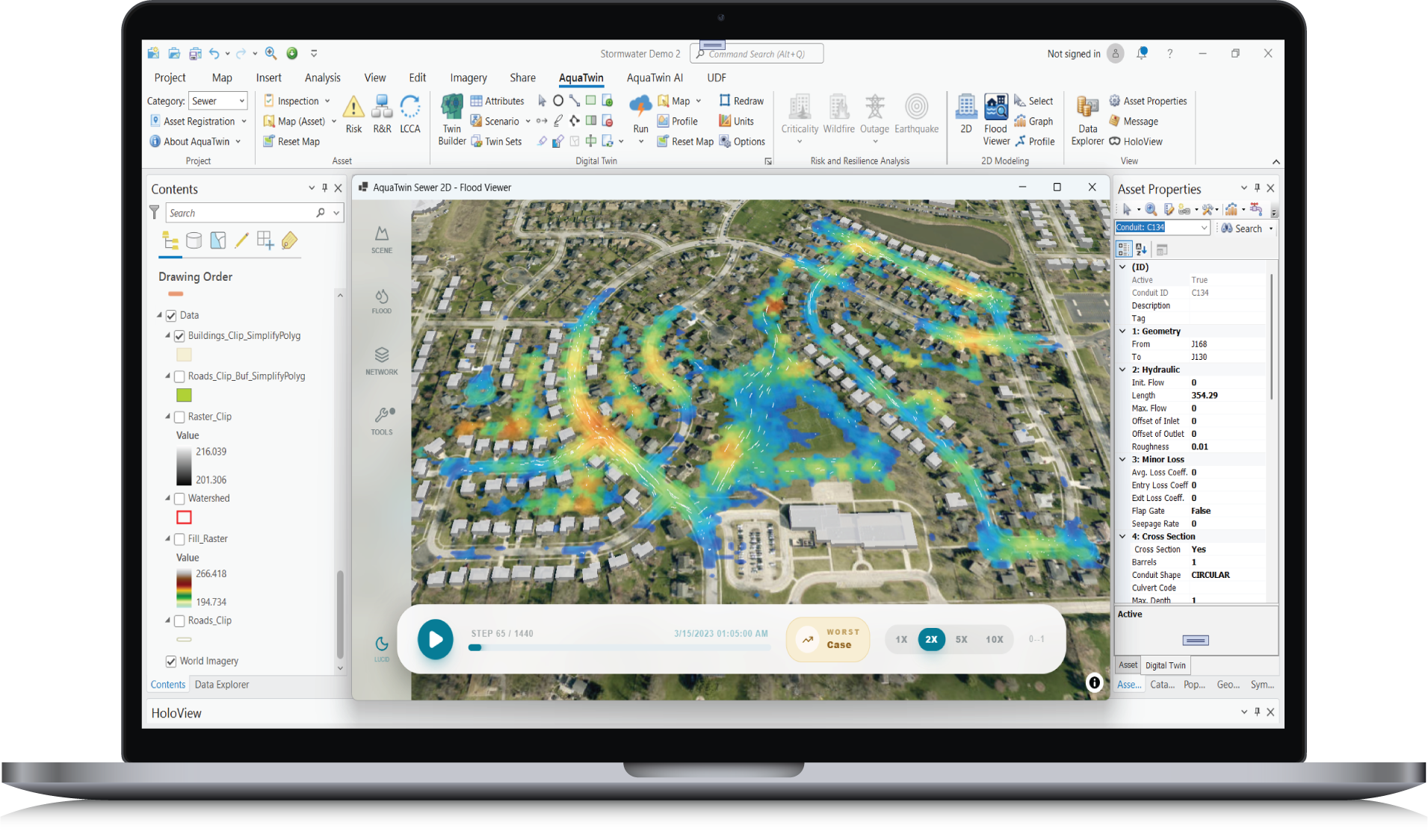
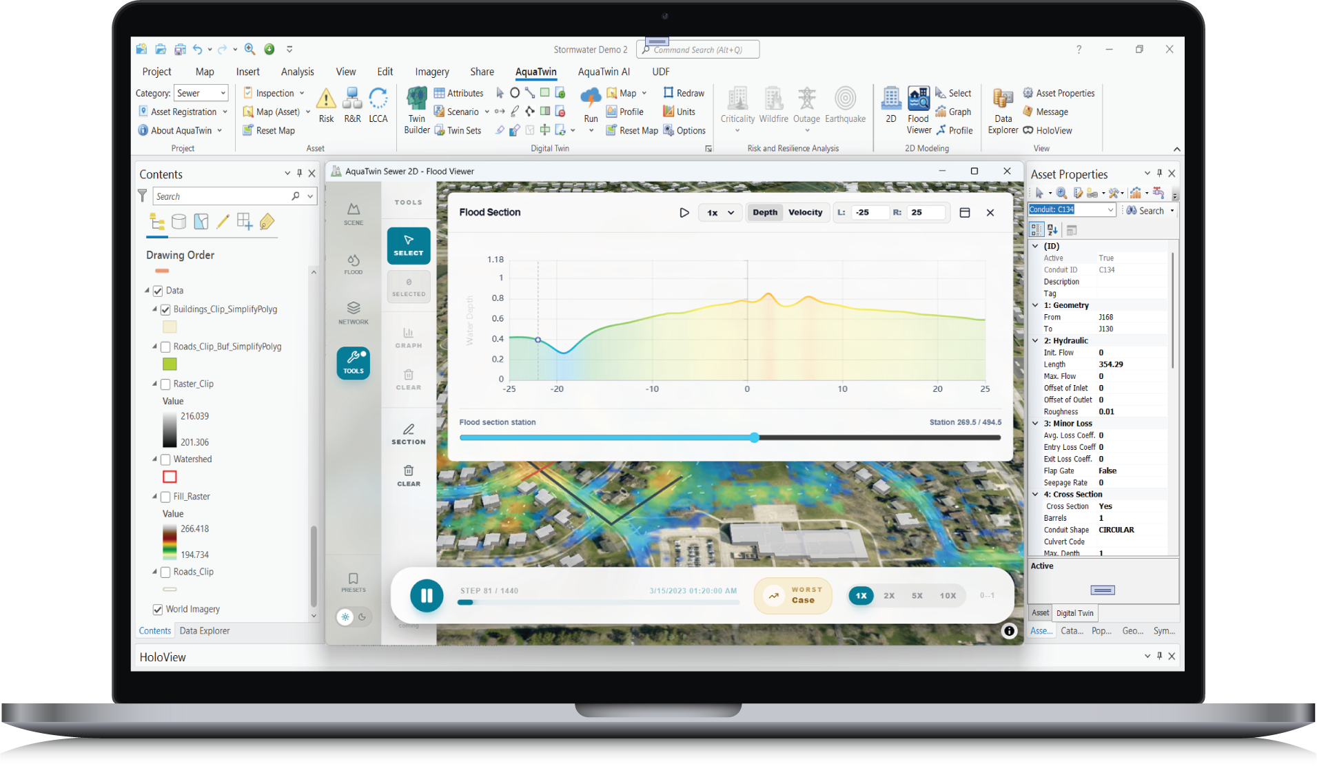
AquaTwin Sewer 2D extends the powerful sewer network modeling capabilities (sub-surface system) of AquaTwin Sewer by giving users the ability to accurately model overland runoff (surface system). It efficiently simulates the dynamic interaction between the sewer network and the overland flow to accurately predict the flood inundation extents. The hydrodynamic simulation of the sub-surface system is solved using the 1D Saint-Venant equations and the hydrodynamic simulation of the surface system inundation is solved using the 2D shallow water equations. The resulting fully integrated 1D-2D model is a very useful and powerful tool in simulating flood extent and flood inundation in urban areas. Different types of 2D boundary conditions can be specified including vertical wall, critical depth, normal depth, supercritical outflow, dry boundary, user-specified boundary water level (e.g., tidal level), inflow time-series, and head-flow rating curves.
AquaTwin Sewer 2D can also run a fully independent 2D simulation without an underlying 1D network. This allows users to model surface runoff and overland flow directly on the 2D mesh. This capability expands AquaTwin Sewer’s analytical scope by enabling standalone 2D surface modeling workflows. And its powerful 3D dynamic flood visualization gives you an intuitive and spatial understanding of flood dynamics and impacted areas to better support your decision-making in flood mitigation and management.
This comprehensive report tests and validates the application of AquaTwin Sewer 2D to the benchmark test suite formalized by the UK Environment Agency, a standard evaluation framework for 2D flood inundation software. The suite spans the full range of 2D flood physics, from wetting/drying fronts, depression filling, and momentum conservation, to transcritical flows and high-resolution urban rainfall and sewer surcharging. AquaTwin Sewer 2D successfully cleared all benchmark test cases. Its advanced 2D explicit shallow water equation (SWE) solver performs reliably for flood risk management, accurately capturing flood extents, velocities, and complex flow dynamics in urban environments.
AquaTwin Sewer: Automated Network Model Skeletonization
AquaTwin Sewer 2D: A Masterpiece in Usability and Performance
AquaTwin Sewer 2D: Propagation of Floodwave over Shallow Depressions
AquaTwin Sewer 2D: Dam-Break Simulation in a Natural Valley
AquaTwin Sewer 2D: Momentum Conservation Over Shallow Berm
AquaTwin Sewer 2D: Wetting, Filling, and Drying Dynamics
AquaTwin Sewer 2D: Levee Simulation in Two Clicks


The “Subcatchment Toolset” automatically delineates subcatchments from digital elevation models (DEMs) based on domain topology, calculate their land areas, and define their characteristics. It automatically:
Use the tractive force (TF) method for self-cleansing design for gravity flow pipes based on critical shear stress.
You can simplify your sewer network model in two ways: reducing and merging.
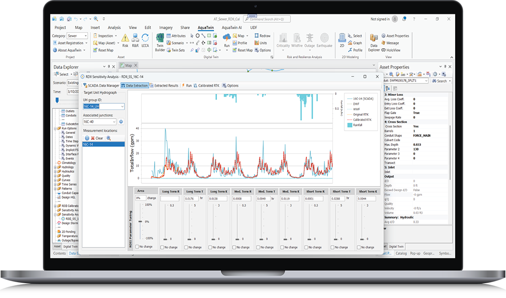
Using intuitive sliders for hydraulic and hydrologic model parameters (including watershed and soil) you can interactively adjust each parameter and simultaneously see how this impacts model results in real-time and how closely it matches measurement data.
Comprehensive Rainfall-Runoff Simulation and Precipitation Analysis
AquaTwin AI Agent transforms how engineers interact with their network models by combining advanced AI agents with powerful water infrastructure modeling capabilities, creating a comprehensive agentic GIS-centric modeling platform. It lets users use AI agents to analyze and troubleshoot network models, schedule and run various simulations, and generate reports and vivid dynamic dashboards using simple natural-language instructions.
Discover the full spectrum of tools and capabilities within the AquaTwin geocentric water infrastructure digital twin today.
Just click below to learn more or for a free demo.